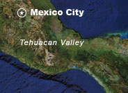
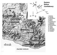
 Confederacy Map of the Alliances dominated by the Eastern Nahuas, Mixtecs, and Zapotecs A.D. 1150-1521. (Google Earth required.)  Tehuacan ValleyArchaeologists have determined that the effigy censer probably came from the Tehuacan Valley located in southern Mexico. Many fragments of these objects have been found there in and around the ruins of ancient palaces. During the Postclassic period between 900 and 1521 C.E., the Eastern Nahuas controlled much of what is today the state of Puebla. Although they were divided into numerous small city-states, the Eastern Nahua maintained unity through their allegiance to a great pilgrimage shrine dedicated to their patron god, Quetzalcoatl or "Plumed Serpent", at the city of Cholula. The Spaniards described Cholula as the "Mecca" of New Spain, while the adjacent Tehuacan Valley to the south funneled gold, turquoise, cacao (chocolate), cotton, and the precious feathers of rare tropical birds among other goods from southern Mexico and Central America to make Cholula's merchants among the richest men in the western hemisphere. Eventually the Eastern Nahuas intermarried with the Mixtecs and Zapotecs of Oaxaca and together their confederacies dominated much of highland Mexico before the rise of their principal rivals the Aztecs of the Basin of Mexico. |


